Thursday, October 11, 2012

Alarm Stage Drought Approaching

Drought Declaration Status: No Drought
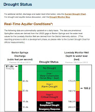
Barton Springs discharge: 39 cfs (40.8 cfs 10-day average)
Lovelady Well:  168.8 ft depth to water (484.6 ft elevation)*

Without significant rainfall and recharge Barton Springs discharge could cross its Alarm Stage drought threshold in mid to late October. The Lovelady well will likely cross its threshold about 2-3 weeks later in early November. It only takes one indicator to cross its threshold for the Board to make a drought declaration.

Despite the better-than-average rainfall for parts of central Texas, the rainfall has not come in sufficient intensity or locations to keep us from entering back into drought conditions.  Streams and rivers are not flowing across the recharge zone and streams such as Onion Creek and the Blanco River are flowing below normal. Surface waters reservoirs such as Lake Travis reflect this fact and are currently at about 42% capacity.

The one glimmer of hope for relief from dry conditions the U.S. Seasonal Drought Outlook indicating this part of central Texas as improving into December. This is likely based upon El Nino conditions projected to strengthen in the next few months.

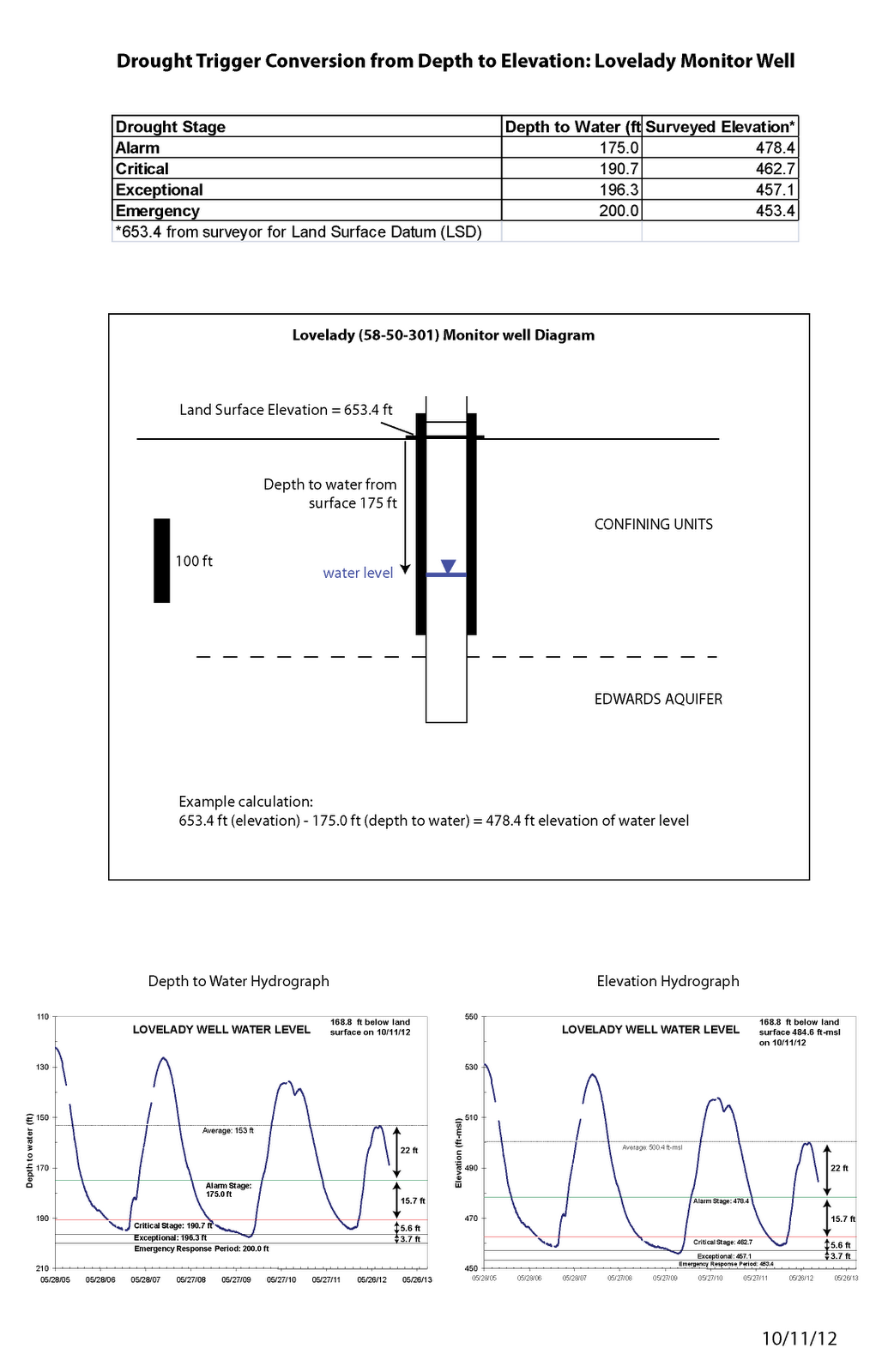
*The Board is on the verge of approving rules that would convert the drought thresholds for the Lovelady well from depth to water (in feet) to an elevation (feet above mean sea level). This is merely a conversion and does not influence the time or frequency of drought declarations from the established methodology.The image below is a summary of those conversions.


Thursday, September 27, 2012

Aquifer Update

Drought Status: No Drought
Barton Springs Flow: 53.8 cfs (10-day average)
Lovelady Elevation: 488.2* (165.2 ft depth to water)

*Note that we have changed the drought trigger thresholds for the Lovelady well. These new triggers will be adopted into the District's recent rule revisions. The new triggers will not materially affect the entry or exit of drought--the method we've developed will function as it always has. However, we had a survey of the well so that we can translate the depth to water from the land surface (in feet) to an accurate water level elevation (in feet above mean sea level).

For example, I measured 165.2 ft depth to water, to get the elevation of the water level I subtract that value from the land surface elevation we had surveyed (653.42 ft above mean sea level). The result is an elevation of the water level in the Lovelady well of 488.2 ft-msl.

The elevation of the Lovelady well is similar to the J-17 well water elevation that is used in the San Antonio segment (http://edwardsaquifer.org/). Today the J-17 elevation is 645.2 ft-msl.


Thursday, September 13, 2012

Alarm Stage Drought approaching

Status: No Drought 
Barton Springs Discharge: 56 cfs daily average (57.9 10-day average)
Lovelady Well: 161.6 depth to water

Both Barton Springs and the Lovelady well are declining rapidly. Barton Springs is declining at a rate of about 0.5 cfs per day and could take us into Alarm Stage II drought conditions by the middle of October if we don't receive significant rainfall soon.

El Nino conditions are thought to be developing and we hope that those conditions will bring about more rainfall than normal and alleviate our dry conditions.

Thursday, August 23, 2012

Aquifer Update

No Drought
Lovelady: 156.1 ft
Barton Springs: 69.3 cfs

Both Barton Springs and Lovelady are declining, although both are well-above their respective drought triggers. NOAA predicts the drought to continue, but with some improvement for Central Texas.

Thursday, August 9, 2012

August Aquifer Update

Drought Status: No Drought
Barton Springs: 74.8 cfs (10-day average)
Lovelady: 153.9 ft

Streamflows in Onion Creek are approaching zero and water levels and Barton Springs are declining as recharge diminishes.  El Nino conditions are likely to develop during August or September according to the NOAA. Hopefully that will bring wetter-than-normal conditions to central Texas.

Wednesday, July 11, 2012

July Aquifer Update

Drought Status: Non-drought
Barton Springs: 77.3 cfs 10-day average
Lovelady: 154.6 ft depth to water

Recent rains over the past couple of days, ranging from 1-4 inches in the BSEACD, have helped alleviate the dryness from a very dry June. However, despite the relatively significant rainfall, very little to no runoff was generated that produced flow in the creeks. Flow in the creeks provides significant recharge to the aquifer.

Given the rate of springflow decline (0.31 cfs/day) over the past two weeks, and without significant recharge, we could expect to reach Alarm Stage Drought sometime in November.

However, conditions in the Pacific Ocean indicate El Nino conditions will develop in July-September.  That generally indicates wetter-than-normal conditions. Let's hope those tendencies hold true!

Wednesday, June 13, 2012

June Aquifer Update

Drought Status: Non-drought conditions
Barton Springs Flow: 86 cfs (87 cfs 10-day average)
Lovelady Depth to Water: 154.6 ft

Thursday, May 10, 2012

May Aquifer Update

Drought Status: Non-drought conditions
Barton Springs: 90.1 cfs (10-day avg)
Lovelady Well: 161.5 ft and rising (depth to water)

More rains are expected to occur in the next 24 hours. With wet conditions in the area (totals up to 2 inches over the past week) more recharge is expected.

Thursday, April 26, 2012

Aquifer Update

Drought Status: No Drought
Barton Springs: 93.1 cfs (10-day average)
Lovelady: 163.1 ft

Flow in the creeks is gradually subsiding and therefore so is recharge. Onion Creek flow at the upper end of the recharge zone was measured yesterday as ~15 cfs.  All of that flow recharged the aquifer within a mile into the recharge zone. Barton Springs reached a peak flow of about 100 cfs and is starting to decline. Water levels in the Lovelady well are still rising, although look like they may be starting to flatten out.

Tuesday, April 17, 2012

Recharge in Onion Creek

Pictured here is a grate over Crippled Crawfish Cave in Onion Creek taken on 4/12/12. This cave and other small solution cavities in the creek are recharging all water that is flowing onto the recharge zone of the Edwards Aquifer, which is about 35 cubic feet per second. Note the small whirlpool in the lower right corner of the photo. Streamflow is diminishing quickly and soon recharge will cease altogether. Hopefully more rains will come this spring to continue the streamflow and recharge into features such as these.

This feature, and others, are on lands owned and operated by the City of Austin for the sole purpose of water quality protection and restoration. A dye trace study in 2005 demonstrated flow from this feature to wells and Barton Springs. The dye arrived at Barton Springs is about 3 days at distance of about 18 miles!